EXECUTIVE SUMMARY
The Vemband Wetland in Kerala is a Ramsar Site, and also a Critically Vulnerable Coastal Area (CVCA). One of the three meeting points of the lake’s waters and the Lakshadweep Sea is at Thottappally in Purakkad Panchayat of Alapuzha. It is a Marma Point. About 600,000 cubic meters of mineral sand has been dredged out from the River Pamba since 2020. As the Coastal Regulation Zone Notification- 2011 prohibits mining in this No-Development Zone, this is packaged as a flood prevention project invoking the District Collector’s emergency powers under the Disaster Management Act 2005. The organisers invented a fake theory that floods are caused by the obstacles like the sandbar at Pozhy and the silt in the leading. The Government claims that Dr MS Swaminathan and the IIT Madras studied the 2018 Kuttanad floods and they recommended removing the obstacles for prevention of floods. This is a lie. MSSRF and IIT-M did not do any study in Kuttanad after 2018; nor did they recommend the dredging for flood prevention. On the contrary, the post-2018 flood study by the Central Water Commission and the Dutch team concluded that the flood was a one-in-a-hundred-year’s heavy rainfall during August 2018, and the human-made structures like dams and regulators had no role in it. The mining began with police protection in May 2020, in spite of the peoples’ resistance and the local government’s objections. Cost-Benefits. The outrage in the River Pamba may have consequences on the water balance of the Vembanad Lake. A preliminary estimate shows that the Thottappally Enterprise yielded a million tons of ilmenite and 85,000 tons of rutile, worth Rs 2000 crores during the past three years. The miners paid about Rs 11 crores as price of the sand. A writ petition against the illegal mining in Thottappally was dismissed by Hon’ble High Court of Kerala on 17 Nov 21. Another petition has been pending with a Division Bench of Kerala HC since 5 Oct 2021. The respondents in that petition may now wish to file fresh submissions, as their original submissions were fictitious.
A lie has its own shelf-life. This lie has survived for 1221 days, undetected during the exchanges in the Kerala High Court, in the National Green Tribunal and in the Kerala Assembly. The sages say that the “face of truth is hidden by a golden leaf”. It is painful to see faces of sages being used to hide the lies.
Mining the River Pamba for Flood Prevention- Novel ideas for evading Regulations: Case Study of Thottappally in Alapuzha, Kerala, India
VT Padmanabhan
Introduction – Location of the Mining Block
Vembanad is one of the six wetlands in India, crowned as Ramsar sites. It is also critically vulnerable coastal area (CVCA), which is to be “managed with the involvement of coastal communities including fisherfolk”. The Lake located in Ernakulam, Alapuzha and Kottayam districts of Kerala has an area of 2033 square kilometres, maximum length of 96 km, and maximum width of 14 km. A narrow barrier island separates it from the Lakshadweep Sea. During the past century, the lake has been heavily reclaimed reducing the water spread area. The lake receives drainage of 10 rivers and accounts for 40% of the area of Kerala. Its annual surface runoff accounts for almost 30% of the total surface water resource of the state. Over 1.6 million people live on its banks. The lake has three meetings points with the Lakshadweep Sea; Thottappally Pozhy in the South is the most important one. This is a “Marma point”. Hitting this may have consequences for the entire lake system.
The Newest Coastal Sand Mining Hub
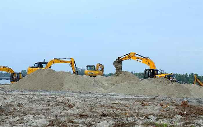
The Thottappally beach in Purakkad Panchayat, Alapuzha district in Kerala, India is poised to become a mining hub for beach sand minerals. The site is in the River Pamba, her last 800 meters path between the Thottappally Spillway and the Pozhy. The mining spots are (a) a 360 m long, 15 m wide sandbar at the Pozhy, (b) 800×360 m area of the River Pamba (also known as leading channel of TSW system), between the spillway bridge and the sea mouth. Mining at Pozhi started in 2020, and it still continues. The mine site is in the No-Development Zone of the CRZ. (See Map).
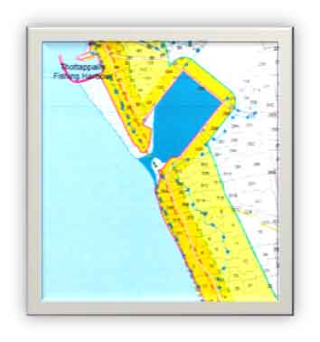 |
Fig. 1: This is from CRZ Map (KL-19 ALP Thottappally-Trikunnapuzha) as in 2015. The inverted bottle is the River Pamba. Thottappally spillway (TSW) bridge on NH 66 is its base. The white +blue dot areas, (CRZ 1-B) inside and on the North coast represents recent accretion. The white- blue -dots area inside the bottle on the Northern side is where the casuarinas were planted in 2005 for tsunami-cyclone mitigation.
Fig. 2: Satellite imagery of Dec 2015. Fig. 3: Imagery in Jan 2022. Mining is transforming the bottle into a perfect rectangle. Area of the stolen land can be estimated from the map) |
| Fig. 1: CRZ Map of the Study Area- in 2015 | Map Explained |

Fig. 2: Thottappally Pozhy- Dec 2015 |

Fig 3: Thottappally Pozhy after mining: Jan 22 |
History of Beach sand mining at Thottappally
The Government of Kerala (GoK) and two beach sand mining companies – The Kerala Minerals and Metals Limited (KMML) and the IREL- Limited had set their eyes on the mineral sand in Thottappally soon after the 2018 floods. On 21 Oct 2018, a high level meeting of the Ministry of Water Resource Development (WRD) decided to de-silt the Thottappally Spill Way (TSW) leading channel for efficient evacuation of Kuttanad’s floodwaters. The GoK reported that the Department of Geology and the National Centre for Earth Science Studies (NCESS) did not provide the data on the concentration of heavy minerals in the sand.
Meanwhile, on 6 May 2019 the Alapuzha District Disaster Management Authority (DDMA) held a meeting to discuss the flood preparedness plans for the district. (Incidentally, the District Disaster Management Programme drafted in 2015 has not been updated after the 2018 flood.) The District Panchayat President, who is the Vice-Chairman of the DDMA, or any other elected official, was not present in the meeting. The District Collector, who is the ex-officio Chairman of the DDMA, ordered the chief engineer of the WRD to remove the obstacles in the leading channel of TSW before the Monsoon, under section 30 of DMA 2005. The chief engineer referred the order to the State Government for further action. It appears that the Kerala State Disaster Management Authority (KSDMA) was not notified about this flood prevention project. The Ministry of Water Resources Development (WRD) issued a Government Order (GO) on 31 May 2019, authorising KMML to collect the sand @ Rs 455 per m3. The first paragraph of the GO reads:
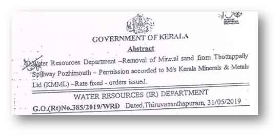
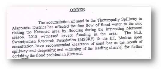
Fig. 4: The Gov Order – Honoring MSSRF
“The accumulation of sand in the Thottappally Spillway in Alappuzha District has affected the free flow of flood water to the sea, risking the Kuttanad area by flooding during the impending Monsoon season. 2018 witnessed severe flooding’ in the area. The MS Swaminathan Research Foundation (MSSRF) & the IIT, Madras upon consultation have recommended clearance of sand bar at the mouth of spillway and deepening and widening of the leading channel for further de-risking the flood problem in Kuttanad.” Emphasis added. (GoK, Water Resources (Ir) Department G.O.(Rt)No.38 S1 2019/WRD Dated 31/05/2019)
The collector’s order of 06 May 2019 and the GoK’s wish to “move forward to avoid the loss of sand during the impending monsoon” were not implemented till May 2020. A meeting of DDMA on 19 May 2020 decided to “restore the efforts to remove the obstacles from the leading channel and sea mouth… under section 26(2) and 34 (a) & (j) of DMA-2005. (The order of 2019 was under section 30). Three days after the DDMA meeting, in the wee hours of 22 May 2020, 1300 policemen trekked to Thottappally to cheer the 100 odd warriors who axed 550 casuarina trees, standing on the beach since 2005. From the next day on, the excavators started scavenging the sandbar. From the month of June 2020, six dredgers hired by the KMML started mining the river, three shifts a day.
In the Kerala High Court and in the NGT
Writ petitions were filed the in the High Court of Kerala by M H Vijayan on 04 June 2020 and S. Seethilal on 04 Oct 2021. The Kerala SDMA is not a respondent in these petitions. The second petition is pending before the Division Bench of Honourable Chief Justice Mr.S.Manikumar and Justice Shaji P.Chaly. The first petition was dismissed by Hon’ble Justice N Nagaresh on 17 Nov 21. The Chennai Bench of NGT also dismissed two original applications on 08 Jul 2022.
Experts from HC Kerala Judgement dated 17 Nov 21
Few paragraphs from the Kerala High Court judgement are reproduced below:
“54. After 2018 Floods, the M.S. Swaminathan Research Foundation and IIT Madras recommended clearance of the Sand Bar at Thottappally Pozhi… It was on the basis of reports of such expert bodies that the authorities under the Act, 2005 decided to de-silt downstream Thottappally and remove the existing sand bar at Pozhi. This is a flood prevention activity and therefore protected by the special provisions in the Disaster Management Act.”
- In the case on hand, the removal of sand bar is intended to obviate impending disaster. Removal of sand bar from downstream of Thottappally Spillway pursuant to the orders passed in exercise of powers under the Disaster Management Act, 2005 would not amount to “mining operations” as defined under Section 3(d) of the Mines and Minerals (Development and Regulation) Act, 1957 for the reason that winning of minerals is not the primary or secondary intent, purport or priority behind the removal of sand bar.
- ….. The steps taken in this case are intended to avert any possible disaster in Pampa, Meenachil, Achankovil, Kuttanad and other areas. Therefore, the orders of the DDMA cannot be said to be ultra vires Section 34 of the Disaster Management Act, 2005. (Emphasis added)
- Ordinarily, laws are framed and are meant to regulate and govern times of peace. The laws meant to govern the times of peace may become insufficient and even hurdles to tackle situations in extra ordinary times like war, calamities, catastrophes, pandemics and disasters. A democratic State should have the power to make such laws which would help to overcome such disasters with least hardship and loss of life and property of its citizens. Section 72 of the Act, 2005 gives overriding effect to the provisions of the Act notwithstanding anything inconsistent there with contained in any other law or in any instrument having effect by virtue of any law other than the Act, 2005.
MS Swaminathan’s name appears five times in the judgement.
The science and engineering backup behind this ‘disaster prevention’ work is summed up below:
a) Kuttanad Floods are caused by the obstacles like the sandbar at Pozhy mouth and silts in the leading channel between the spill-way bridge and the Pozhy at Thottappally.
b) After the 2018 flood, MS Swaminathan and IIT-Madras authored a report on flood control measure to be implemented at Thottappally.
c) Expert bodies “strongly recommend” the periodic removal of these obstacles as the only way to prevent floods in Kuttanad and the flood-plains of the River Pamba.
d) The district collector has special power to get these works done under the Disaster Management Act, by-passing any other Act and Rules.
e) Such orders can be challenged only in a High Court or the Supreme Court.
Diagnostics of 2018 flood
According to the reports of the Central Water Commission and the Joint Report of the GoK- Dutch Disaster Reduction team, the 2018 flood was caused due to the extreme rainfall events in August, which was a one-in-hundred years’ event. The Thottappally Spillway (TSW) was designed during the 1940’s to evacuate about one-third of the maximum flood waters of the River Pamba from Vembanad Lake to the Lakshadweep Sea. It could not achieve its design flow rate of 1820 m3/second, as the 300 m wide leading channel from Thottappally to Veeyapuram (for about 11 km) was not constructed. The maximum evacuation during 1960’s was 600 m3/s. The Dutch scientists Paul van Meel, and Simon Warmerdam reported that the “drainage channel system, including the main drain into which the four main rivers drain into the Kuttanad wetlands, have poor maintenance and have to some extent silted up, thus reducing their drainage discharge capacities towards the TSW, which itself has a limited capacity of reportedly 380 m3/s”. The consensus opinion is that the Thottappally SW spillway could only evacuate about 10% of floodwaters, because of the bottlenecks upstream Thottappally. The Dutch team, which worked together with the experts from WRD, did not recommend dredging and excavation downstream the spillway. They even had doubt as to whether the removal of the sandbar is necessary, as they recommended:
“to increase considerably the discharge to the outlet by adjusting the channel that connects the Pamba river to the Thottappally outlet (channel alignment, adjustment of depth, removal of obstacles). It is possible that in this case it is no longer necessary to dredge the sandbar, because the natural stream power is enough to flush away the bar. Kerala IWRM Action Plan Kuttanad Basin, (Page 46) 25 March 2019.
In short, the 2018 flood of Kuttanad was not caused due to the bottlenecks downstream the TSW.
A Non-Existent Study
Did MSSRF and IIT conducted a study during or after 2018 Kuttanad flood?. The answer is No.
Then, how and why their names appear in a Gov order, affidavits of the respondents and in the judgement?
In response to the Vijayan’s petition in the High Court, the IREL submitted an exhibit -“the relevant pages of the report by MS. Swaminathan Research Foundation (MSSRF) dated 13/02/2007”. The list of exhibits filed in the writ petition does not have any report from IIT-M.
MSSRF published their report of agrarian distress in Kuttanad in August 2007, not on 13 Feb 2007. It is this study which is referred to as the study after 2018 floods. MSSRF recommended modernisation of TSW, and a new technical study of the Spillway. In 2011 Jayakumar KV from the Centre for Water Resource Development Management (CWRDM), Kozhikode and Prof B S Murty from the IIT Madras published their report on TSW. Even though the TSW was flagged off in both the reports, the interventions they recommended were upstream the spillway. Modernisation of TSW was implemented in the Kuttanad package before 2018. The main recommendation of increasing the river width from 80-100 m to 300 m from Veeyapuram to Thottappally has not been implemented.
In short, dredging the River Pamba at her confluence with the Sea was not recommended by MSSRF and IIT even in their reports before the 2018 flood.
The Estimated Extraction and the Volume of Business
Full details of the sand extracted in R Pamba at Thottappally since May 2020 are not available in the public domain. The website of WRD shows the data for 192 days from 16 May to 23 Nov 2021. According to a report of the Comptroller and Auditor General, during 20 May- 15 Jul 2020 (56 days), 242,831 cub meter of sand was dredged from the River Pamba. Onmanorama.com reported that the mining in Thottappally was “completed in four months (May thru August) in three shifts each day” in 2020.
The volume of minerals reportedly gained in 2020 and 2021 is 479,841 m3 This volume will contain 978,876 tons of heavy minerals. M. Sundararajan and colleagues from the Department of Environmental Sciences, University of Kerala, and the CSIR-National Institute for Interdisciplinary Science and Technology (CSIR-NIIST), Thiruvananthapuram have reported the concentration of mineral in beach sands of Kollam and Alapuzha coast. The estimation of minerals gained is based on the above report.
The heavy minerals constitute about 51% of the raw sand. As per the contract, the non-mineral fraction of the sand was to be disposed of locally. The contract between the GoK and the KMML stipulates separating the minerals from the raw sand at Thottappally and disposal of non-mineral fraction locally. The KMML is transporting away the entire raw sand as they did not install the spirals for separating the minerals at Thottappally. (There are other breaches of contracts which will be discussed later on.) I presume that the volumes reported are for the raw sand.
479,841 m3 of raw sand mined during 2020 and 2021, contains 241650 m3 or 978,876 tons of heavy minerals. This includes 56,506 tons of rutile and 641,402 tons of ilmenite. Estimate of the price of the minerals is based on the sale price of ilmenite and rutile in 2020 at the IREL’s Chavara site, published in The Indian Minerals Yearbook-2020. The sale prices in 2020 per ton of these minerals are Rs 92,138 and Rs 14,618 respectively. The collections during 2020 and 2021 were worth Rs 1,458 crores. If the yield in 2022 is similar to the previous years, this business is worth Rs 2,100 crores.
The price of the mud paid to the treasury by the mining company in two years is Rs 11 crores. If the operation were named as mining, the State could have received a royalty of Rs 210 crores + Rs 21 crores as contribution towards the District Mineral Fund.
The Social and Environmental Cost of a Unique Disaster Prevention Project
The operation began in May 2020, when the State was experiencing the pandemic disruptions. The inaugural of the operation was really majestic with the deployment of 1300 police personnel cheering a hundred odd wood cutters who axed 540 casuarinas in the wee hours of the morning on 20 May 2020. Denying the rights of the village Panchayat and the local fishing community, dredging of the Pozhi and the River started on the next day. The police unleashed extreme brutality against people who were protesting against the transportation of minerals. The Secretary of the Panchayat was transferred within 24 hours for asking questions to the miners. Incidentally, the casuarinas garden was raised under the social forestry program for mitigation of tsunami and other disasters from the Sea. During its 14 years of existence, the plantation did not cause any flood. This also was a picnic and selfy spot of the neighbourhood people.
Thottappally beach was a nesting ground of Olive Ridley turtles. They have not been visiting the beach since the takeover by the KMML.
Kerala experienced the worst flood of a century causing 498 deaths and displacement of 1.4 million people in 2018. The area, depth and duration of inundation were higher in Kuttanad than in other Taluk in the State. Majority of the people who became homeless have not been rehabilitated.
This is the first “flood control project in India” initiated by invoking the emergency powers vested in the District Collector under the Disaster Management Act of 2005. It survived the trials in the High Court and the NGT on the strength of an invented theory of flood, and attribution of its authorship to Dr MS Swaminathan and the IIT-Madras. These invented lies have been immortalised in a Gov Order, CAG’s Audit report, counter affidavits filed by the respondents and in the judgements of High Court and the NGT. Each lie has its own shelf-life. This one survived for 1221 days.
To Sum up:
The respondents – the GoK and the mining companies lied to the High Court of Kerala and the National Green Tribunal about non-existent studies.
There is no expert body recommendation for the present sand mining work in Thottappally portion of the River Pamba,
These activities will not improve the efficiency of spillage of floodwaters.
The activities did not and will not mitigate or reduce the flood hazards in Kuttanad.
The emergency powers of the District Collectors are limited to rescue and relief operations, which are done during a disaster, in which even a few minutes of delay may have disastrous consequences. The work started some 380 days after the promulgation. This delay did not cause any harm to anyone. And therefore, the collector’s activities at Pozhy and downstream
The district collector’s order for preventing flood and saving lives, under the emergency powers in the Disaster Management Act 2005, has caused a bigger disaster in the governance, in the academics and in the judiciary. Digging a tank, depth up to -10 m MSL, may adversely impact the entire water body of the Vembanad Lake.
VT Padmanabhan is a researcher working on health effects of ionizing and non-ionizing radiation, nuclear safety, coastal zone management, corona-virus pandemic etc. He has published his findings in Counter Currents, peer-reviewed journals. Most of his papers are available at the www.reseearchgate.net.

