Industrial Revolutions and the Great Acceleration in the second half of the 20th century, witnessed the planet, irrevocably transitioning from the Holacene epoch to the Anthropocene era. Unbridled human activity, rampant urbanization, mechanization of production, proliferation of factories, industrial scale manufacture and employment of fertilizers and pesticides and the resultant emission of greenhouse gases have adversely impacted nature. Environmental degradation, cllimate change and climatic pattern reversals – El Nino and La Nina – have reached an inflection point, threatening the very existence of the most dangerous species on the planet- humans.
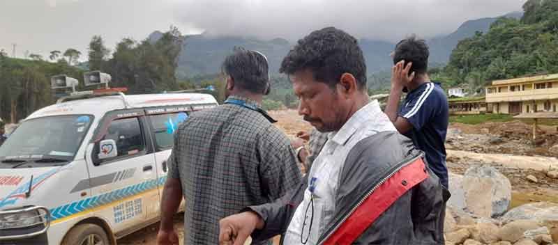
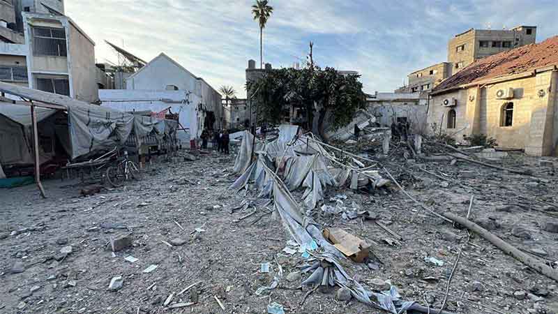
On the night of July 30th, 2024, the serene and idyllic district of Wayanad in Kerala succumbed to nature’s fury when three successive landslips devastated – in a span of few hours – picturesque settlements of Chooralmala, Punjirimattom, Attamala and Mundakkai in Meppadi panchayat (village council). At the break of dawn, the lush, verdant and rolling hilly landscape vanished and was transformed into a valley of death and destruction, carnage and mayhem. The death toll has risen to over 400 and with over 115 people missing, the Wayanad landslide of 2024, remains the most deadly and biggest landslip disaster in the history of the south Indian state of Kerala. Initial reports from the meterological department suggested that heavy rainfall caused the tragedy. Before the event, the region experienced torrential rainfall in excess of 572 millimeters in the preceding 48 hours, leading up to the disaster.
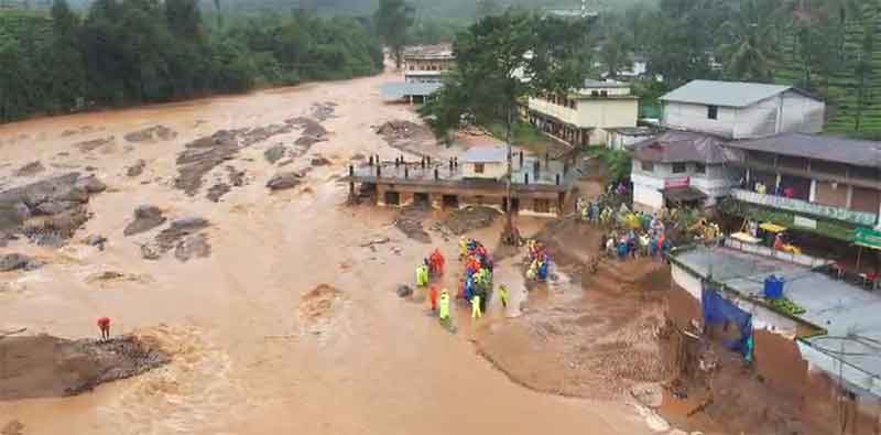
On August 1, Indian Space Research Organization’s (ISRO), National Remote Sensing Center (NRSC) released a satellite imagery, that depicted the magnitude of the tragedy. Around 86,000 square metres of land had been displaced from the povenance of the first landslide. The run-out zone was estimated to be 8 kms from atop the hill and along the catchment area of Iruvanchipuzha, a major tributary of Chaliyar river that originates deep inside the Western Ghats. The first slip that had its epicenter, around 6 kilometres deep within the dense forest, caused such widespread destruction in the lower reaches of the hilly terrain replete with human habitation, has a plausible explanation- that of unrestricted and prohibitive anthropogenic activity detrimental to ecology. Commercial activities of agriculture, construction and quarrying have disrupted the ecological balance, that accelerated the environmental degradation of the hilly terrain of the Western Ghats.
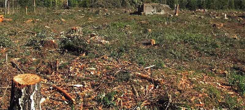
Deforestation for agriculture and cultivation of cash crops like rubber, cardamom, tea and coffee intensified during the British rule. Over a period of few hundred years, the integrity of the top soil was compromised and it became weak and susceptible to mass wasting. The hydrological conditions of the soil impacted the pattern of water discharge. When large trees were uprooted for slash and burn clearance for farmlands, the massive roots remained intact and formed subterranean cavities on decay. These interconnected root systems quickly transformed into subterranean flowage channels, leading to soil piping and ground collapse. When water carrying capacity of the soil deteriorates due to anthropogenic factors, it then adversely impacts slope stability and hydrological properties of the terrain in reducing surface run-off, increases infilteration and alters water conductivity of the underlying soil layers.
Experts from National Center for Earth Science Studies (NCESC), have surmised in a preliminary report that “Dam-Burst Effect”, could be the likely cause of the landslip. Excessive rainfall led to the formation of a temporary dam in the water-logged terrain, and this barrage could have collapsed with the onslaught of sodden topsoil discharge of soggy mud and debris, uprooting trees and dislodging huge boulders and the furious run-down decimating settlements on its downward course.
The hilly regions of Kerala adjoining the Western Ghats are especially susceptible to landslides. World Weather Attribution, a renwoned international group that studies the correlation between climate change and catastrophic weather events have linked, as part of their ongoing research that human-induced climate change as the likely malefactor of Wayanad landslides. Reports have indicated a 62% reduction in forest cover in the Western Ghats coupled with rampant quarrying activities have imperilled slope stability. When forests are cleared for commercial ventures, the consequence is enhanced global warming. Global temperatures are 1.3 degrees higher than the pre-industrial levels, that exponentially increase the probability of occurrence of such geographical catastrophes like landslides with increasing frequency. The Ministry of Earth Sciences vouched in the Lok Sabha that between 2014 and 2020, 62% of landslides reported in the country, occurred in Kerala.
In recent years, human-induced climate change has resulted in overheating of the Arabian Sea. Meterologists and climate-scientists have observed higher frequency of short cloudbursts over southern regions adjoining the Arabian Sea. Intense heating of the sea surface results in evaporation and condensation into large cumulo-nimbus clouds, reaching heights of 15 kilometers. These cumulo-nimbus, rain clouds consolidate to form massive mesoscale convenctive systems and when they encounter topographical barriers like the Western Ghats, they engender intense, localized rainfall. This phenomenon is called a cloudburst.
Tea plantations adorn the landslide affected villages and most of the residents are employed as plantation workers. The society is primarily agrarian and reside in the valleys between hillocks. The swamps that function as natural drainage of mountains were reclaimed and used for constructing accomodation for the workers. These settlements built over swamps further impeding drainage of water after heavy precipitation, exposing them to insurmountable risks in the event of a natural disaster. Indiscriminate land use in the ecologically fragile Western Ghats has been a gnawing problem, exacerbating extreme weather events.
The Wayanad tragedy reignited the intense debate over the 2011 Western Ghats Ecology Expert Panel Report (EEPR), ubiquitiously known as Gadgil Committee Report. Madhav Gadgil, an ecologist and conservationist and his team had constitued a scholarly report on the ecological fragility and environmental vulnerability of the Western Ghats. The committee recommended large swathes of Western Ghats, which, 137,000 square kilometers – over 80% of forest land – spread over six states to be notified as Ecologically Sensitive Area (ESA). But most state governments rejected it, citing such notification impacts already existing population engaging in restricted activities – like agriculture and plantation – in the report. Gadgil Report had segregated the forest land into three ecologically sensitive zones and elucidated the activities permitted in each zone.
While many state governments covered under the jurisdiction of the report had reservations in implementing en toto, Kerala state government summarily rejected the report. Another commission was set up, called Kasturirangan Committee, to study how Gadgil report could be modified in consonance with ground realities in the region. Critics argue that, Kasturirangan Report not only reduced the area to 80,000 square kilometers, originally delienated as ecologically sensitive area (ESA), but also paved the way for connivance with regulatory apparatus to continue issuing licenses for prohibitive activities in the Gadgil Report. The state of Kerala vehemently opposed it, and many of the clauses and directives were diluted to accommodate the interests of the deeply entrenched political parties and local population and who had settled there for centuries. Those villages were reclassified as natural landscape and not protected zones. As a consequence of the new Kasturirangan Report, settlements that came under the purview of protected in Gadgil Report, were enlisted as natural landscape, and calamitous activities for the fragile ecosystem like mining and quarrying continue unabated under regulatory approval.
Kerala, has an illustrous track record of exmplary disaster management, with timely and meritorious participation of state, public and private stakeholders as witnessed during the devastating floods in 2018 and Covid-19 pandemic. The economic costs of crisis and disaster management are staggering. While it cost the exchequer 40,000 crores for rescue and rehabilitation of 2018 flood victims, the projected outlay required for the combined disaster adaptation and mitigation according to a report by Kerala State’s Action Plan on Climate Change (2023-2030) is 90,000 crores.
The need of the hour is a proactive disaster mitigation program that hinges on local landslide early warning systems (LEW), community involvement, advance techniques like seismic noise imaging and incorporating run-down flowpath into disaster management models. Private agencies like HUME Center For Wildlife Biology could give early warning signals to district authorities based on measurement of rainfall, but has no technology, systems and models to assess the ferocious flow. Nature and natural systems are not dependent on man, but the converse is true. When abused rather than used, nature simply will arrange things that its laws are impossible to transgress.
Jayakhosh Chidambaran is a management consultant and researcher.