Some four months ago, a devastating flood ravaged the Chamoli district in the Indian Himalayas, killing over 200 people. The flood was caused by a massive landslide, which also involved a glacier. Researchers at the University of Zurich, the Swiss Federal Institute for Forest, Snow and Landscape Research (WSL) and ETH Zurich have now analyzed the causes, scope and impact of the disaster as part of an international collaboration.
A news release by the University of Zurich (EurekaAlert and the American Association for the Advancement of Science, AAAS, June 10, 2021) said:
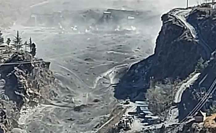
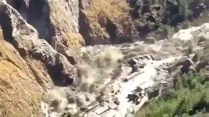
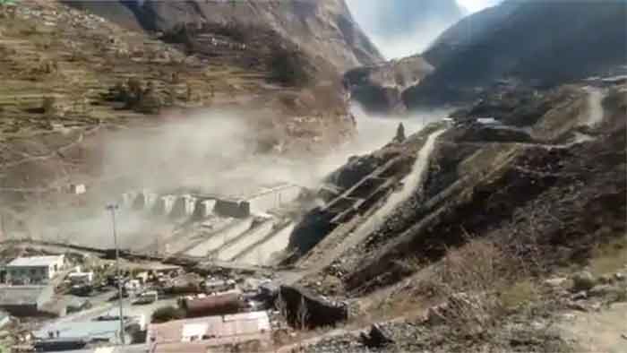
On February 7, 2021, a massive wall of rock and ice collapsed and formed a debris flow that barreled down the Rishiganga and Dhauliganga river valleys, leaving a trail of devastation. The flood took more than 200 lives and destroyed two hydropower plants as well as several roads and bridges. A large international team including researchers from the University of Zurich (UZH), the WSL and the ETH Zurich came together immediately after the disaster and began to investigate the cause and scope of the flood and landslide. Their study used satellite imagery, digital models of the terrain, seismic data and video footage to reconstruct the event with the help of computer models.
Avalanche of rock and ice
Twenty million cubic meters of rock had broken off from Ronti peak in Chamoli district in Uttarkhand at about 5,500 meters above sea level, including a steep hanging glacier with about 5.5 million cubic meters of ice. The massive avalanche, made up of rock (80%) and ice (20%), hurtled down the valley and the narrow gorge. Resulting energy from the friction melted almost all of the ice and led to a devastating mudflow.
The international cooperation analyzing the extreme event was coordinated by GAPHAZ, a scientific group of leading experts on glacier and permafrost hazards in mountains. Holger Frey from UZH’s Department of Geography and GAPHAZ board member says: “The speed and breadth with which we analyzed the disaster is unprecedented. Only five years ago, having such extensive and high-resolution satellite imagery available so quickly was almost unthinkable.”
Research work started immediately
The UZH researchers have been working in the Indian Himalayas for several years and were contacted by the Indian government’s National Disaster Management Authority (NDMA) only hours after the event. In the days that followed, they were able to provide the Indian authorities with initial insights on how the disaster unfolded and the processes involved. “Among other things, our reports and assessments were used to plan the on-site investigation,” says Frey.
Hazardous hydropower projects
The deaths of more than 200 people, most of whom were non-local workers, and the destruction of the two hydropower plants added fuel to the ongoing debate about power plant projects in fragile alpine ecosystems. Following the devastating floods in Uttarakhand back in 2013, the hydropower industry was accused by the Supreme Court of India of having exacerbated the consequences of such floods with its practices. “The Chamoli disaster sadly confirms that many hydropower companies operating in the Himalayas are not doing enough to survey and monitor the increasingly unstable alpine environment,” says co-author Christian Huggel from the UZH Department of Geography.
Impacts of climate change
The effects of climate change can also be felt below the surface. Temperatures inside mountains are rising in permafrost regions, increasing the likelihood of rockslides in alpine zones. Given the growing energy requirements in the Himalayan states, this problem is expected to get worse. “The Chamoli disaster was a rare extreme event,” says Holger Frey. “But it’s only a matter of time before the next such massive event will happen somewhere in the Himalayas.” With several additional hydropower plants in planning, fast and sustainable solutions are needed – as well as close collaboration with scientists. “We must take advantage of the most advanced technologies and knowledge to better protect human lives and assets in the future,” Christian Huggel says. Such rare disastrous events cannot be ruled out for other mountain regions either, and they can have disastrous effects, especially in regions with relative dense infrastructure such as the Alps.
Other media reports said:
Imagine a wall of rock and ice 1,800 feet wide falling the length of four Empire State Buildings stacked end-to-end.
A slab that size is responsible for the disaster in northern India that killed more than 200 people and destroyed two power plants four months ago, according to a new study published Thursday.

Overview of the Chamoli disaster. (A) 3D rendering of the local geography, with labels for main place names mentioned in the text. HPP stands for hydropower project. (B to D) Pre- and post-event satellite imagery of the site of the collapsed rock and glacier block, and the resulting scar. Note snow cover in the region just before the event (C). The red arrows in (C) mark the fracture that became the headscarp of the landslide [(22), §3.2] (fig. S4). The arrow in D points to a remaining part of the lower eastern glacier. (E) 3D rendering of the scar. (F) Schematic of failed mass of rock and ice. Satellite imagery in (A) to (D) and (E) is from Sentinel-2 (Copernicus Sentinel Data 02-10-2021) and Pléiades-HR (© CNES 02-10-2021, Distribution AIRBUS DS), respectively.
Just before dawn on February 7, a massive chunk broke off a glacier on Ronti Peak in the Indian Himalayas. The slab dropped more than a mile into the valley below, from its position roughly 18,000 feet above ground, at almost 134 miles per hour.
As the chunk landed, the rock disintegrated and the ice melted, creating a wall of water and debris that swiftly funneled into the river valley below. From there, the mixture cascaded toward the Rishiganaga and Tapovan hydropower plants. After a curve in the valley slowed the sludge down, it swept into tunnels underneath the plants at speeds of up to 56 miles per hour, trapping and killing many workers inside.
The severity of the event, known as the Chamoli disaster, initially stumped scientists. Typically, landslides in the region do not kickstart floods as rapid or lengthy as the one that occurred in February.
“A ‘normal’ dry rock avalanche would not have traveled as far as this one did – in other words, would not have reached either the Rishiganga or Tapovan hydroplants,” said Dan Shugar, a geoscientist at the University of Calgary and co-author of the new study.
Shugar’s team discovered key elements that could explain the disaster’s severity: The initial avalanche’s composition (about 20% ice and 80% rock), coupled with its mile-long fall, resulted in a hyper-mobile torrent of debris that doomed workers in the valley below.
The researchers calculated that the flood was 27 million cubic meters in volume – enough to cover more than 1,600 football fields in 10 feet of debris and still have some left over.
The flood climbed 722 feet up the valley walls
Flooding and landslides are not uncommon in Uttarakhand, the area where Chamoli is located. In 2013, heavy rainfall set off devastating floods in the area than killed up to 5,700 people.
After the February disaster, experts initially thought a lake near the top of Ronti Peak had burst after the chunks of glacier holding it together cracked or broke off. Some glacial lakes can hold hundreds of millions of cubic meters of water.
But satellite imagery showed there were no such lakes along the debris flow’s path.
By analyzing maps of the valleys’ terrain, video footage of the event, and earthquake data in the area, Shugar’s team was able to reconstruct what happened.
The chunk of glacier that broke off Ronti Peak in the early morning was, on average, 262 feet thick. When it touched down at the mountain’s base, the slab flattened a section of nearby forest, and threw a thick dust cloud into air. The impact with the valley floor was so violent that the rock and ice therein blended together to form a flood that climbed 722 feet up the valley walls.
It was “almost the ‘optimal’ combination” for melting glacier ice, said Holger Frey, a glaciologist at the University of Zurich in Switzerland. The massive flood, he added, “facilitated the large reach and destructive nature of this disastrous event.”
‘It’s only a matter of time’ until a disaster like this happens again
The flood caught workers at the hydroplants in Chamoli by surprise.
But according to the study, an early warning system could have given workers six to 10 minutes of notice before the flood reached them. Seismic sensors – which monitor rumblings in the Earth for signs of earthquakes or shifting rock – can detect when an avalanche happens and let workers know if a flood is on its way.
Even if the Chamoli disaster couldn’t have been prevented, Frey said, “a well-designed warning system should be able to warn workers at these plants and allow them to seek safe grounds.”
After all, the conditions that led to the Chamoli disaster aren’t going to disappear any time soon.
Evidence from other mountainous regions, like Alaska, suggests glacier-related landslides are increasing in frequency as the climate warms, according to Shugar.
“I expect this would be similar in high mountain Asia,” he said.
Rising air and surface temperatures are linked to more instability in glaciers and an increasing likelihood of landslides high in the mountains. The warmer the Earth becomes, the more glaciers shrink.
“It’s only a matter of time before the next such massive event will happen somewhere in the Himalayas,” Frey said in a press release.
The study (Science 10, June 2021: eabh4455
DOI: 10.1126/science.abh4455) by D. H. Shugar, M. Jacquemart, D. Shean, S. Bhushan, K. Upadhyay, A. Sattar, W. Schwanghart, S. McBride, M. Van Wyk de Vries, M. Mergili, A. Emmer, C. Deschamps-Berger, M. McDonnell, R. Bhambri, S. Allen, E. Berthier, J. L. Carrivick, J. J. Clague, M. Dokukin, S. A. Dunning, H. Frey, S. Gascoin, U. K. Haritashya, C. Huggel, A. Kääb, J. S. Kargel, J. L. Kavanaugh, P. Lacroix, D. Petley, S. Rupper, M. F. Azam, S. J. Cook, A. P. Dimri, M. Eriksson, D. Farinotti, J. Fiddes, K. R. Gnyawali, S. Harrison, M. Jha, M. Koppes, A. Kumar, S. Leinss, U. Majeed, S. Mal, A. Muhuri, J. Noetzli, F. Paul, I. Rashid, K. Sain, J. Steiner, F. Ugalde, C. S. Watson, M. J. Westoby said:
Steep slopes, high topographic relief, and seismic activity make mountain regions prone to extremely destructive mass movements. The sensitivity of glaciers and permafrost to climate changes is exacerbating these hazards. Hazard cascades, where an initial event causes a downstream chain reaction, can be particularly far-reaching, especially when they involve large amounts of water.
The study report said:
Between 1894 and 2021, the Uttarakhand Himalaya has witnessed at least 16 major disasters from flash floods, landslides, and earthquakes.
Human activities that intersect with the mountain cryosphere can increase risk and are common in Himalayan valleys where hydropower development is proliferating due to growing energy demands, the need for economic development, and efforts to transition into a low-carbon society. Hydropower projects in Uttarakhand and elsewhere in the region have been opposed over their environmental effects, public safety, and issues associated with justice and rehabilitation.
The scientists estimated the onset of this avalanche and its velocity by analyzing seismic data from two distant stations, 160 and 174 km southeast of the source.

Satellite-derived elevation data of the Chamoli hazard cascade. (A) Perspective view of the area, from the landslide source at Ronti Peak to the Rishiganga and Tapovan Vishnugad hydropower projects (black stars). (B) Elevation change over the landslide scar based on DEM-differencing between September 2015 and February 10-11, 2021. (C) The proximal valley floor, with geomorphic interpretations of the flow path. (D) Confluence of Ronti Gad and Rishiganga River. (E to J) Topographic profiles showing elevation change due to rock/icefall and sediment deposition for locations shown in (B) to (D). Elevation loss on the inner bank in (J) is primarily due to the destruction of forest.
The study report said:
The lowermost part of the larger eastern glacier is still in place and was not eroded by the rock and ice avalanche moving over it, suggesting that the avalanche may have become airborne for a short period during its initial descent. Optical feature tracking detected movement of the failed rock block as early as 2016, with the largest displacement in the summer months of 2017 and 2018. This movement opened a fracture up to 80 m wide in the glacier and into the underlying bedrock.
It cited media reports: Some ice blocks (diameter <1 m) were found in tunnels at the Tapovan Vishnugad hydropower site, and some videos of the debris flow show floating blocks that we interpret as ice, indicating that some of the ice survived at considerable distance downstream. Notably, and in contrast to most previously documented rock avalanches, very little debris is preserved at the base of the failed slope. This is likely due to the large volumes of water that resulted in a high mobility of the flow.
The report said:
After the rock and ice avalanche impacted the valley floor, most of it moved downvalley in a northwesterly direction. Frictional heating of the ice in the avalanche generated liquid water that allowed the transition in flow characteristics, becoming more fluid downvalley, creating a flow consisting of sediment, water, and blocks of ice.
It said:
The mass flow traveled downvalley and superelevated (runup elevation) up to ~130 m above the valley floor around bends.
At the confluence of the Ronti Gad and Rishiganga River, a ~40 m thick deposit of debris blocked the Rishiganga valley. Deposition in this area probably resulted from deceleration of the mass flow at a sharp turn to the west. During the days following the event, a lake ~700 m long formed behind these deposits in the Rishiganga valley upstream of its confluence with Ronti Gad. The lake was still present two months later and had grown since the initial formation. Substantial deposition occurred about 1 km downstream of the confluence, where material up to ~100 m thick was deposited on the valley floor. DEM differencing shows that the total deposit volume at the Ronti Gad-Rishiganga River confluence and just downstream was ~8×10⁶ m3.
A field reconnaissance by co-authors from the Wadia Institute of Himalayan Geology indicates that the impact of debris flow material (sediment, water, ice, woody debris) at the confluence of Rishiganga River with Dhauliganga River created a bottleneck and forced some material 150-200 m up the Dhauliganga. The release of the water a few minutes later led to the destruction of a temple on the north bank of the Dhauliganga.
A substantial fraction of the fine-grained material involved in the event was transported far downstream.
Approximately 24 hours after the initial landslide, the sediment plume was visible in PlanetScope and Sentinel-2 imagery in the hydropower project’s reservoir on the Alaknanda River at Srinagar, about 150 km downstream from the source. About 2½ weeks later, increased turbidity was observed at Kanpur on the Ganges River, ~900 km from the source. An official of the Delhi water quality board reported that 8 days after the Chamoli disaster, a chief water source for the city – a canal drawing directly from the Ganga River – had an unprecedented spike in suspended sediment (turbidity) 80 times the permissible level. The amount of corresponding sedimentation in hydropower reservoirs and rivers is unknown, but possibly substantial, and may contribute to increased erosion on turbine blades, and infilling of reservoirs in the years to come.
Causes and implications
The report said:
The February 7 rock and ice avalanche was a very large event with an extraordinarily high fall height that resulted in a disaster due to its extreme mobility and the presence of downstream infrastructure. The ~3700 m vertical drop to the Tapovan HPP is surpassed clearly by only two known events in the historic record, namely the 1962 and 1970 Huascaran avalanches, while its mobility (H/L = 0.16 at Tapovan, where H is fall height and L is flow length) is exceeded only by a few recent glacier detachments. The location of the failure was due to the extremely steep and high relief of Ronti Peak. The sheared nature of the source rocks and contrasting interbedded rock types likely conditioned the failure. The large and expanding fracture at the head scarp may have allowed liquid water to penetrate into the bedrock, increasing pore-water pressures or enhancing freeze-thaw weathering.
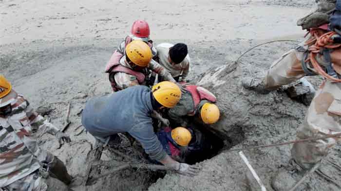
Nearly all (190) of the 204 people either killed or missing in the disaster were workers at the Rishiganga (13.2 MW) and Tapovan (520 MW) project sites. Direct economic losses from damage to the two hydropower structures alone are over US$ 223 million. The high loss of human life and infrastructure damage was due to the debris flow, and not the initial rock and ice avalanche. However, not all large, high-mountain rock and ice avalanches transform into highly mobile debris flows that cause destruction far from their source.
Our energy balance estimates indicate that most of the volume of glacier ice first warmed (along with a portion of the rock mass) from approximately -8°C to 0°C and then melted through frictional heating during the avalanche as it descended to the Rishiganga valley, involving a drop of approximately 3400 m. Potential other sources of water were considered, including glacier lake outburst floods, catastrophic drainage of water from reservoirs such as surface lakes, ice deposited by earlier avalanches, and enlithic reservoirs. No evidence for such sources was observed in available remote sensing data. A slow-moving storm system moved through the area in the days before Feb 7. We estimate that a ~220,000–360,000 m3 contribution from precipitation over the Ronti Gad basin was a minor component of the flow, representing only 4-7% of the water equivalent contained in the initial glacier ice detachment. Similarly, while water already present in the river, water ejected from groundwater, melting snow, wet sediment, and water released from the run-of-the-river hydroelectric project may have all contributed to the debris flow, even when taken together (with generous error margins), these sum to a small amount compared to the probable range of water volumes in the mass movement. The major effect of ice melt on the mobility of rock and ice avalanches is documented, but it appears that the combination of the specific rock/ice fraction (~80/20% by volume) and large fall height of the rock and ice avalanche led to a rare, severe event during which nearly all of the ice melted.
It said:
Soon after the disaster, media reports and expert opinions started to circulate, postulating links of the event to climate change. Recent attribution studies demonstrated that glacier mass loss on global, regional and local scales is to a large extent attributable to anthropogenic greenhouse gas forcing. High-mountain slope failures in rock and ice, however, pose additional challenges to attribution due to multiple factors and processes involved in such events. While long-term trends of increasing slope failure occurrence in some regions could be attributed to climate change, attribution of single events such as the Chamoli event remains largely elusive. Nevertheless, certain elements of the Chamoli event have potential links to climate, and weather, as described below. Furthermore, the Chamoli event may be seen in the context of a change in geomorphological sensitivity and might therefore be seen as a precursor for an increase in such events as climate warming proceeds.
The stability of glacierized and perennially frozen high-mountain slopes is indeed particularly sensitive to climate change. Our analysis suggests regional climate and related cryospheric change could have interacted in a complex way with the geologic and topographic setting to produce this massive slope failure. Air and surface temperatures have been increasing across the Himalayan region, with greater rates of warming during the second half of the 20th Century and at higher elevations. Most glaciers in the Himalaya are shrinking and mass loss rates are accelerating across the region. Glacier shrinkage uncovers and destabilizes mountain flanks and strongly alters the hydrological and thermal regimes of the underlying rock.
The detachment zone at Ronti Peak is about 1 km higher than the regional lower limit of permafrost at around 4,000 to 4,500 m asl., as indicated by rock glaciers in the region and global permafrost maps. Exposed rock on the north face of Ronti Peak likely contains cold permafrost with rock temperatures several degrees below 0°C. In connection with glaciers, however, ground temperatures can be locally higher. The ice-free south face of Ronti Peak is certainly substantially warmer with rock temperatures perhaps around or above 0°C, causing strong south-to-north lateral heat fluxes. Permafrost temperatures are increasing worldwide, in particular in cold permafrost, leading to long-term and deep-seated thermal anomalies, and even permafrost degradation. Increasing ground temperatures at the failure site of the Chamoli avalanche could have resulted in reduced strength of the frozen rock mass by altering the rock hydrology and the mechanical properties of discontinuities and the failed rock mass.
The report said:
Videos of the event, including the ones broadcast on social media in real time, showed that the people directly at risk had little to no warning. This leads us to question what could have happened if a warning system had been installed. We estimate that a suitably designed early warning system might have allowed for 6 to 10 min of warning before the arrival of the debris flow at the Tapovan project (perhaps up to 20 min if situated near the landslide source, or if a dense seismic network was leveraged, which may have provided enough time to evacuate at least some workers from the power project. After the event, a new flood warning system was installed near Raini. Studies show that early warning system design and installation is technically feasible but rapid communication of reliable warnings and appropriate responses by individuals to alerts, are complex. Previous research indicates that effective early warning requires public education, including drills, which would increase awareness of potential hazards and improve ability to take action when disaster strikes. Considering the repeated failures from the same slope in the past two decades, public education and drills in the Chamoli region would be very beneficial.
At the conclusion, the report said:
We identified three primary drivers for the severity of the Chamoli disaster: (1) the extraordinary fall height, providing ample gravitational potential energy; (2) the worst-case rock:ice ratio, which resulted in almost complete melting of the glacier ice, enhancing the mobility of the debris flow; and (3) the unfortunate location of multiple hydropower plants in the direct path of the flow.
As well as having a previous history of large mass movements, the mountain is riven with planes and points of structural weakness, and further bedrock failures as well as large ice and snow avalanches are inevitable.
If appropriate human resources and technologies are in place, post-disaster analysis can be reduced to days or hours.
Although we cannot attribute this individual disaster specifically to climate change, the possibly increasing frequency of high-mountain slope instabilities can likely be related to observed atmospheric warming and corresponding long-term changes in cryospheric conditions (glaciers, permafrost). Multiple factors beyond those listed above contributed to the Chamoli rock and ice avalanche, including the geologic structure and steep topography, possible long-term thermal disturbances in permafrost bedrock induced by atmospheric warming, stress changes due to the decline and collapse of adjacent and overlying glaciers, and enhanced melt water infiltration during warm periods.
The Chamoli event also raises important questions about clean energy development, climate change adaptation, disaster governance, conservation, environmental justice, and sustainable development in the Himalaya and other high-mountain environments. This stresses the importance of a better understanding of the cause and impact of mountain hazards, leading to disasters. While the scientific aspects of this event are the focus of our study, we cannot ignore the human suffering and emerging socio-economic impacts that it caused. It was the human tragedy that motivated the authors to examine available data and explore how these data, analyses, and interpretations can be used to help inform decision-making at the ground level.
The disaster tragically revealed the risks associated with the rapid expansion of hydropower infrastructure into increasingly unstable territory. Enhancing inclusive dialogues among governments, local stakeholders and communities, private sector, and the scientific community could help assess, minimize, and prepare for existing risks. The disaster indicates that the long-term sustainability of planned hydroelectric power projects must account for both current and future social and environmental conditions, while mitigating risks to infrastructure, personnel, and downstream communities. Conservation values carry elevated weight in development policies and infrastructure investments where the needs for social and economic development interfere with areas prone to natural hazards, putting communities at risk.
GET COUNTERCURRENTS DAILY NEWSLETTER STRAIGHT TO YOUR INBOX